|
|
|
|
|
Results, Write-up, and photos for September 20-22nd, 2005 MAPSS Downeast Problem Soils Tour The photo below is a landscape view of The Great Heath, as seen from the ice-contact north slope of the Pineo Ridge glaciomarine delta. 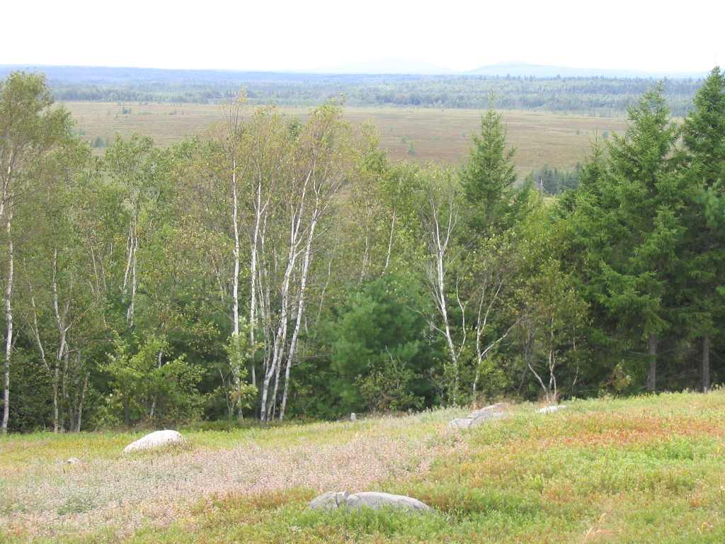
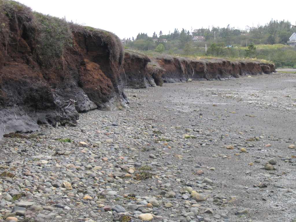
The following 2 photographs are from Carrying Place Bluffs. In the first, note the increasing humification with depth, as visible plant and wood fibers become progressively more decomposed, yielding a more hemic and blacker texture and color. The peat transitions to a sapric, black, possible lacustrine sediment immediately above the gray, silty clay, marine sediments. Marine molluscs dating to 13,500 years before present were observed in the marine sediments here. The second photo shows severe coastal erosion in progress. 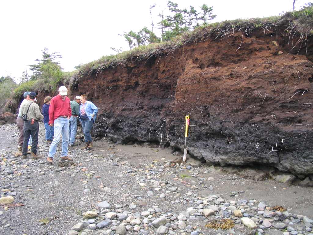
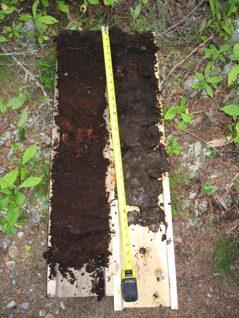
The two box monoliths show a typical Creasey soil, although this would be a variant as a Poorly Drained member. Note the Ranunculus hispidus(likely), Glyceria sp. grasses, Rubus hispidus, Viola sp., Solidago rugosa (likely), and other hydrophytes. At the base of the monolith on the left, note the typically occuring red matrix color inherited from the red sedimentary sandstone/conglomerate bedrock underlying this part of Maine. 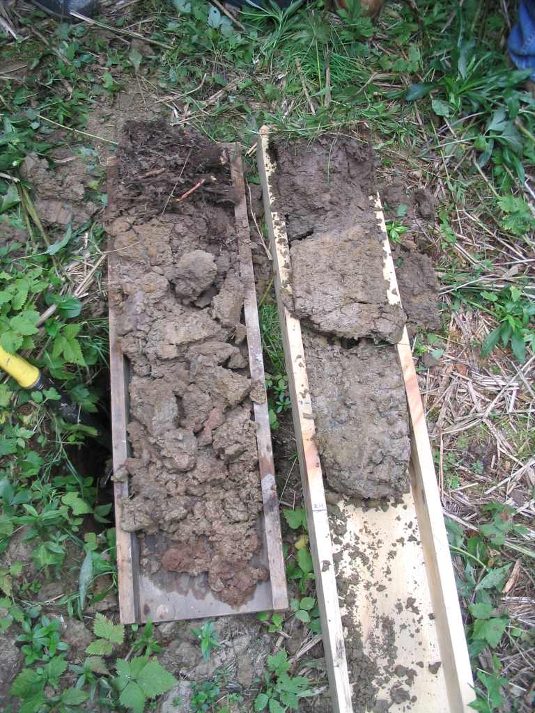
The Bold Coast, near West Quoddy Head light. The bedrock here is part of the coastal volcanic rock terrane, and was once part of Africa. Note the typically occuring cool, foggy weather and resultant spruce-fir boreal forest. 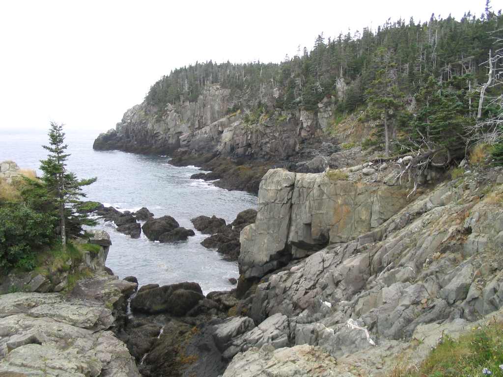
On the left photo, note a typically occuring folist. This organic soil was found on a small, convex knoll along the coastal boreal forest. It is freely drained. In contrast, the right photo shows a histosol (>16 inchs or organic material at the surface) resulting from prolonged wetness (>30 days saturation). It was taken from a small drainage swale ~20 feet away from the folist. Water was observed in the soil pit within several inches of the ground surface.
MAPSS 2005 DOWNEAST HYDRIC SOILS TOUR
by David Rocque On September 21, 2005 a group of about 15 enthusiastic participants converged at the Bluebird Motel in Machias to begin day 1 of a 2-day hydric soils workshop sponsored by MAPSS. The first stop was in Perry at the Pleasant Point Passamaquoddy Indian Reservation. We looked at a poorly drained marine sediment that was downslope of and influenced by Creasy soils, derived from red conglomerate sandstone. These soils did not classify as being hydric but were determined to have poorly drained hydrology by monitoring water tables. Most troubling was the color of the Ap horizon, which was not dark enough (value above 3 and/or chroma above 2), a problem throughout New England according to participants from the week before representing the Field Indicators for Identifying Hydric Soils In New England Technical Committee. The lack of low chroma redox depletions or a low chroma matrix beneath of the Ap was attributed to influence by the Creasy soils upslope. Members did however, note redox features throughout the Ap horizon in the pit that was determined to be the wettest, a fact that will be taken into consideration by Field Indicators Committee Members during the upcoming field season and may find its way into a future version of the hydric soils identification document. Stop 2 was in Lubec at West Quoddy Head State Park. The focus of this stop was organic soils where a folist was compared to a wet histosol, separated by about 20 horizontal feet. There was a distinct difference in position in the landscape but little difference in vegetation. These soils are strongly influenced by the microclimate of being adjacent to very cool ocean water. As a case in point, the site was visited on July 27, 2005, to describe the soil pits. It was over 90 degrees F in most of the state and 88 degrees in Machias that day, but only 55 degrees at the site with a strong wind off the water and fog so thick it was dripping off from trees like rainfall. The main soil profile differences were rooting depth and soil structure. The folist and the part of the histosol above the seasonal high water table exhibited granular structure, while the part of the histosol below the seasonal water table had massive structure. The folist had many roots of all kinds throughout but the histosol had most of the roots above the seasonal water table. The final stop of day 1 was at Cobscook Bay State Park for a lobster and clambake prepared by the Washington County Soil and Water Conservation District. The food was great, the weather perfect and the scenery spectacular. No one complained about not getting his or her moneys worth. Day 2, stop 1 was at Roque Bluff State Park . This stop was to observe old beach or dune sand deposits located between a freshwater pond and the ocean. One interesting factor affecting seasonal water table depths in soils pits at this site is the influence of the rise and fall of the ocean tides. While on site with the Field Indicators Technical Committee the week before, we observed a water table drop of 7 inches in one hour as the tide was receding. The presence of sulfidic materials in some of the pits reinforced the tidal influence. This site was also complicated by what appeared to be the addition of fill, probably during the construction of the park and access road. The final stop on the tour was in Jonesboro to look at wet spodosols. Attendees struggled with distinguishing between indicators of the podzolization process and the formation of redoximorphic features in these soils. In particular, much discussion focused on identification of redoximorphic features (including a stripped matrix) in the E horizon. The Field Indicators failed to correctly identify two of the pits as hydric, even though water table monitoring had previously determined wetland hydrology was present. The Field Indicators Technical Committee is aware of this problem and is currently working on new indicators for spodosols. The only pit at this stop that could be classified as hydric was one that was comprised of an O and E horizon over bedrock, if the E horizon was mistakenly identified as a horizon with a depleted or gleyed matrix. This was an informative workshop with much interesting discussion amidst spectacular scenery and wonderful late summer/early fall weather. Successful workshops such as this one only happen because of the hard work and cooperation of a number of individuals and groups. MAPSS wishes to thank NRCS for their considerable assistance, particularly Area Soil Resource Specialists Ron Olson and Dave Wilkinson. Also, thanks go to the Passamaqouddy Indian Tribe for providing one of the stops and in particular to Dana Altvater who assisted in obtaining water table depths and temperatures at several sites. We thank the Maine Department of Conservation for allowing us to use State Park Lands, free of charge, including for the lobster bake and in particular Tim Hall who supervises park managers. Finally, we want to thank the Washington County Soil and Water Conservation District for doing a wonderful job of putting on the lobster bake (including homemade pies), particularly Nate Pennell and Sharon Foss.
|
|
© 2005 MAPSS, All rights reserved. Contact: info@mapss.org
[ Site Developed by Kenbrio ] |